Not a fact anymore

Earth’s continents and ocean basins occupy essentially fixed positions.

What we know now

Earth’s rigid outer layer is divided into tectonic plates that move relative to one another. Continents form parts of these plates and are carried along as the plates move.

Why it changed

Ocean-floor mapping, seafloor spreading, symmetrical magnetic patterns in oceanic crust, the ages of seafloor rocks, and the global distribution of earthquakes and volcanoes produced a unified explanation for continental movement during the 1950s and 1960s.

Status
Superseded
Category
Earth Science
Accepted for
≈115 years
Accepted approximately
19th century to the mid-20th century
Changed approximately
1950s–1960s
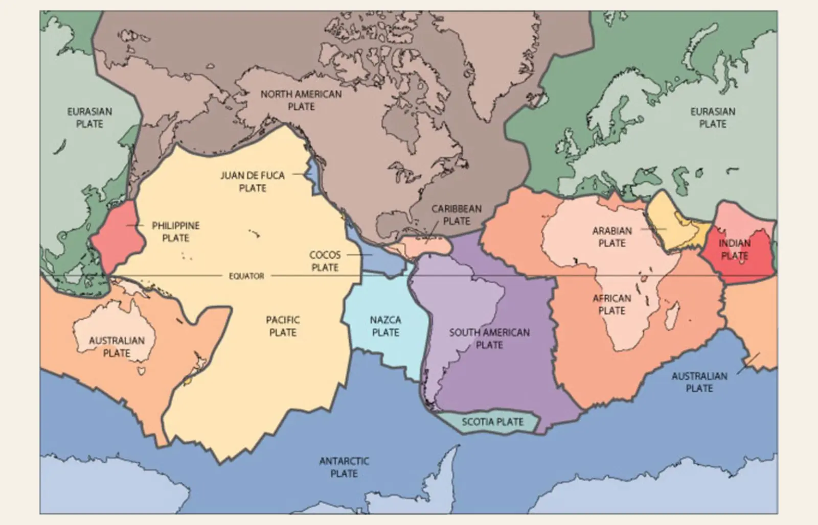
Generalized world map of tectonic plates, with major plates shown in different colors and labeled; dark boundary lines trace where the plates meet.

A modern tectonic-plate map makes visible the framework that replaced fixed continents and ocean basins: Earth’s surface is divided into moving plates, and the continents form parts of those plates.

U.S. Geological Survey, This Dynamic EarthU.S. Geological Survey: View source ↗Public domainConverted for web display

By the early twentieth century, geology had strong evidence for ancient seas, mountain building and large vertical changes in Earth’s crust, but most geologists still treated continents and ocean basins as fundamentally fixed in their horizontal positions.

Alfred Wegener challenged that framework in 1912. The fit of continental margins, matching fossils and geological structures across oceans suggested that continents had once been joined and later separated. Many geologists rejected continental drift, however, because Wegener lacked a convincing mechanism and his continents appeared to require ploughing through resistant oceanic crust.

The decisive evidence came from the ocean floor. Sonar mapping revealed mid-ocean ridges; seafloor-spreading models proposed that new crust formed there; magnetic surveys found symmetrical stripes recording geomagnetic reversals on either side of the ridges; and oceanic crust became progressively older away from them. Earthquake and volcano belts outlined the boundaries of moving lithospheric plates.

By the 1960s, plate tectonics unified these observations. Continents move because they are embedded within larger plates, not because they independently push through stationary seafloor.

Plate motion can now be measured directly. Research continues into the early history and detailed driving forces of plate tectonics, but the fixed-Earth framework it replaced is no longer viable.
Evidence

Sources and what they establish

Previous belief

Historical context

Current evidence

  • What is a tectonic plate?U.S. Geological Survey

    Explains that Earth’s outer shell is divided into moving tectonic plates and that continents form parts of those plates.

  • Plate Tectonics: The Unifying Theory of GeologyU.S. National Park Service

    Explains the ocean-floor mapping, paleomagnetic evidence, seafloor spreading, and related discoveries that led to acceptance of plate tectonics.

  • How fast do tectonic plates move?U.S. Geological Survey

    Explains that plate motion can now be measured directly and that different plates move at different speeds and in different directions.

Related entries

Or go somewhere else: